National view and regional collapse
USDA Agricultural Research Service. Rangeland Analysis Platform. In: Rangeland Analysis Platform [Internet]. 2023 [cited 11 Dec 2023]. Available: https://rangelands.app/
Data exclude areas of cropland, development, and water. Data use the historical satellite record to track vegetation loss in grasslands and rangelands and may not be suitable in forested areas.
World Wildlife Fund. 2023 Plowprint Report. In: World Wildlife Fund [Internet]. 25 Oct 2023 [cited 11 Dec 2023]. Available: https://www.worldwildlife.org/publications/2023-plowprint-report
Species
Northern Bobwhite Brennan LA, Hernández F, Williford D. Conservation and management. In: Northern Bobwhite (Colinus virginianus) [Internet]. 4 Mar 2020 [cited 30 Aug 2023]. Available: https://birdsoftheworld.org/bow/species/norbob/cur/conservation
U.S. Geological Survey. BBS trends 1966-2019. In: Eastern Ecological Science Center - Bird Population Studies [Internet]. 2019 [cited 29 Aug 2023]. Available: https://www.mbr-pwrc.usgs.gov/
eBird Status and Trends. Data version: 2021. Fink, D., T. Auer, A. Johnston, M. Strimas-Mackey, S. Ligocki, O. Robinson, W. Hochachka, L. Jaromczyk, A. Rodewald, C. Wood, I. Davies, A. Spencer. 2022. eBird Status and Trends, Data Version: 2021; Released: 2022. Cornell Lab of Ornithology, Ithaca, New York. https://doi.org/10.2173/ebirdst.2021
Photo by Chad Hutchinson/Macaulay Library
Pronghorn Kauffman MJ, Copeland HE, Berg J, Bergen S, Cole E, Cuzzocreo M, et al. Ungulate migrations of the western United States, Volume 1: U.S. Geological Survey Scientific Investigations Report 2020–5101. U.S. Department of the Interior, U.S. Geological Survey; 2020. doi:10.3133/sir20205101
Photo by Wenfei Tong
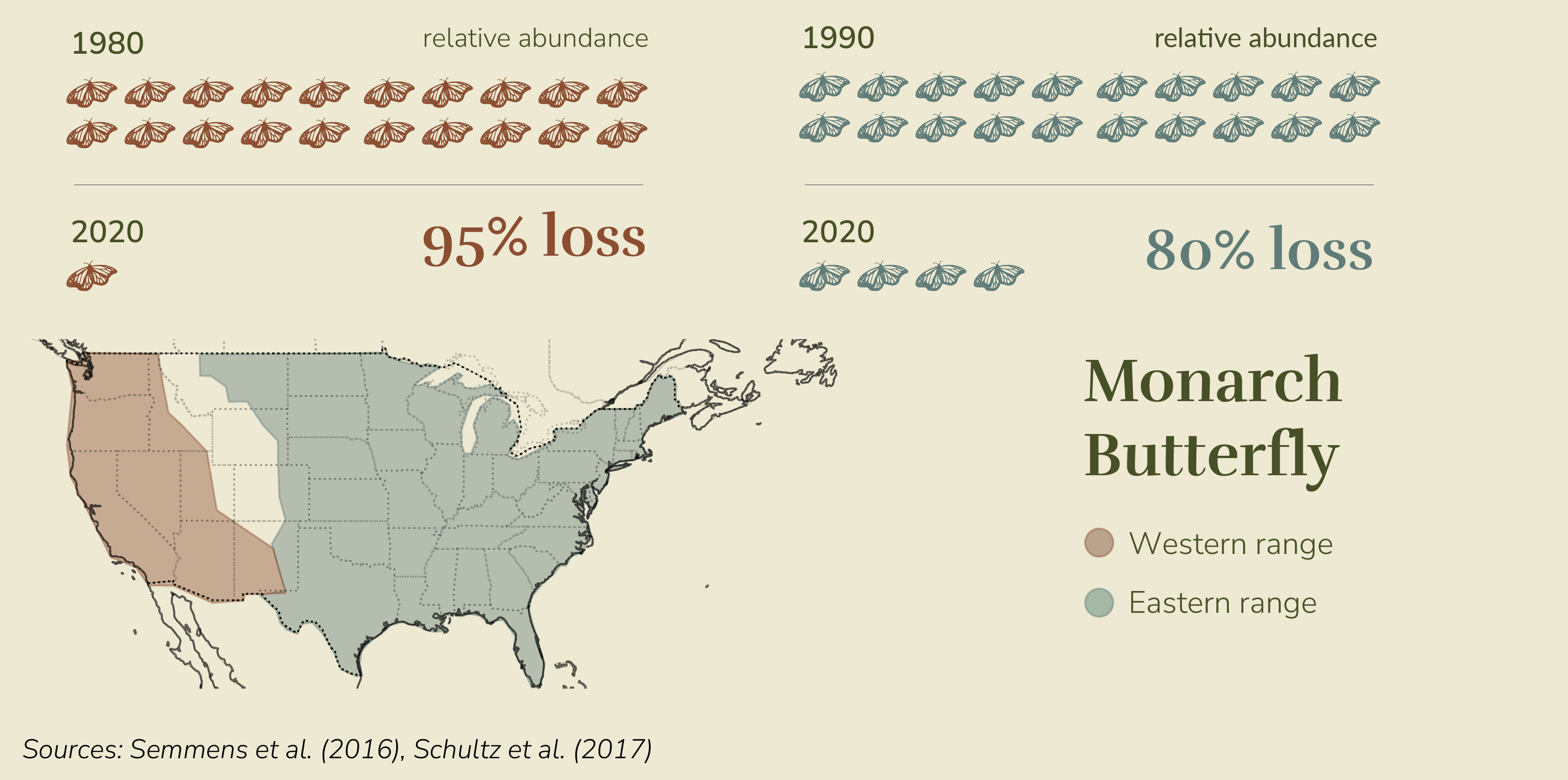
Monarch Butterfly Semmens BX, Semmens DJ, Thogmartin WE, Wiederholt R, López-Hoffman L, Diffendorfer JE, et al. Quasi-extinction risk and population targets for the Eastern, migratory population of monarch butterflies (Danaus plexippus). Sci Rep. 2016;6: 23265.
Schultz CB, Brown LM, Pelton E, Crone EE. Citizen science monitoring demonstrates dramatic declines of monarch butterflies in western North America. Biol Conserv. 2017;214: 343–346.
Xerces Society for Invertebrate Conservation https://www.xerces.org/monarchs
Photo by Rod M.
Greater Prairie-Chicken Johnson JA, Schroeder MA, Robb LA. Behavior. In: Greater Prairie-Chicken (Tympanuchus cupido) [Internet]. 4 Mar 2020 [cited 30 Aug 2023]. Available: https://birdsoftheworld.org/bow/species/grpchi/cur/behavior
Lautenbach JM, Plumb RT, Robinson SG, Hagen CA, Haukos DA, Pitman JC. Lesser Prairie-Chicken avoidance of trees in a grassland landscape. Rangeland Ecol Manage. 2017;70: 78–86.
Photo by Jonathan Fiely
Rio Grande Cutthroat Trout Trout Unlimited. State of the trout: a report on the status and trends of native trout in the United States. Arlington, VA; 2015.
Western Native Trout Initiative. Rio Grande Cutthroat Trout (Oncorhynchus clarkii virginalis). 2016 May.
Photo by Patrick Clayton Engbretson
Northern Pintail Clark RG, Fleskes JP, Guyn KL, Haukos DA, Austin JE, Miller MR. Conservation and management. In: Northern Pintail (Anas acuta) [Internet]. 4 Mar 2020 [cited 29 Aug 2023]. Available: https://birdsoftheworld.org/bow/species/norpin/cur/conservation
U.S. Fish and Wildlife Service. Waterfowl population status, 2022. Washington, D.C. USA: U.S. Department of the Interior; 2022. Available: https://www.fws.gov/media/waterfowl-population-status-2022
eBird Status and Trends. Data version: 2021. Fink, D., T. Auer, A. Johnston, M. Strimas-Mackey, S. Ligocki, O. Robinson, W. Hochachka, L. Jaromczyk, A. Rodewald, C. Wood, I. Davies, A. Spencer. 2022. eBird Status and Trends, Data Version: 2021; Released: 2022. Cornell Lab of Ornithology, Ithaca, New York. https://doi.org/10.2173/ebirdst.2021
Photo by Matt Misewicz/Macaulay Library
Ring-necked Pheasant U.S. Geological Survey. BBS trends 1966-2019. In: Eastern Ecological Science Center - Bird Population Studies [Internet]. 2019 [cited 29 Aug 2023]. Available: https://www.mbr-pwrc.usgs.gov/
Whitmore RW, Pruess KP, Gold RE. Insect food selection by 2-week-old Ring-Necked Pheasant chicks. J Wildl Manage. 1986;50: 223–228.
eBird Status and Trends. Data version: 2021. Fink, D., T. Auer, A. Johnston, M. Strimas-Mackey, S. Ligocki, O. Robinson, W. Hochachka, L. Jaromczyk, A. Rodewald, C. Wood, I. Davies, A. Spencer. 2022. eBird Status and Trends, Data Version: 2021; Released: 2022. Cornell Lab of Ornithology, Ithaca, New York. https://doi.org/10.2173/ebirdst.2021
Photo by Rachel Bush
Elk Kauffman MJ, Copeland HE, Berg J, Bergen S, Cole E, Cuzzocreo M, et al. Ungulate migrations of the western United States, Volume 1: U.S. Geological Survey Scientific Investigations Report 2020–5101. U.S. Department of the Interior, U.S. Geological Survey; 2020. doi:10.3133/sir20205101
Photo by Wenfei Tong
Bobolink U.S. Geological Survey. BBS trends 1966-2019. In: Eastern Ecological Science Center - Bird Population Studies [Internet]. 2019 [cited 29 Aug 2023]. Available: https://www.mbr-pwrc.usgs.gov/
North American Bird Conservation Initiative. The State of the Birds, United States of America, 2022. 2022. Available: https://www.stateofthebirds.org
eBird Status and Trends. Data version: 2021. Fink, D., T. Auer, A. Johnston, M. Strimas-Mackey, S. Ligocki, O. Robinson, W. Hochachka, L. Jaromczyk, A. Rodewald, C. Wood, I. Davies, A. Spencer. 2022. eBird Status and Trends, Data Version: 2021; Released: 2022. Cornell Lab of Ornithology, Ithaca, New York. https://doi.org/10.2173/ebirdst.2021
Photo by Brad Imhoff/Macaulay Library
Scaled Quail Zornes M, Bishop RA. Western Quail Management Plan. Williamson SJ, editor. Cabot, VT: Wildlife Management Institute; 2009.
Dabbert CB, Pleasant G, Schemnitz SD. Conservation and management. In: Scaled Quail (Callipepla squamata) [Internet]. 4 Mar 2020 [cited 29 Aug 2023]. Available: https://birdsoftheworld.org/bow/species/scaqua/cur/conservation
McIntosh MM, Holechek JL, Spiegal SA, Cibils AF, Estell RE. Long-term declining trends in Chihuahuan desert forage production in relation to precipitation and ambient temperature. Rangeland Ecol Manage. 2019;72: 976–987.
U.S. Geological Survey. BBS trends 1966-2019. In: Eastern Ecological Science Center - Bird Population Studies [Internet]. 2019 [cited 29 Aug 2023]. Available: https://www.mbr-pwrc.usgs.gov/
eBird Status and Trends. Data version: 2021. Fink, D., T. Auer, A. Johnston, M. Strimas-Mackey, S. Ligocki, O. Robinson, W. Hochachka, L. Jaromczyk, A. Rodewald, C. Wood, I. Davies, A. Spencer. 2022. eBird Status and Trends, Data Version: 2021; Released: 2022. Cornell Lab of Ornithology, Ithaca, New York. https://doi.org/10.2173/ebirdst.2021
Photo by Ad Konings
Greater Sage-Grouse U.S. Geological Survey. BBS trends 1966-2019. In: Eastern Ecological Science Center - Bird Population Studies [Internet]. 2019 [cited 29 Aug 2023]. Available: https://www.mbr-pwrc.usgs.gov/
Photo by Brian Genge/Macaulay Library
Mallard Drilling N, Titman RD, McKinney F. Habitat. In: Mallard (Anas platyrhynchos) [Internet]. 4 Mar 2020 [cited 30 Aug 2023]. Available: https://birdsoftheworld.org/bow/species/mallar3/cur/habitat
Doherty KE, Ryba AJ, Stemler CL, Niemuth ND, Meeks WA. Conservation planning in an era of change: state of the U.S. Prairie Pothole region. Wildl Soc Bull. 2013. doi:10.1002/wsb.284
eBird Status and Trends. Data version: 2021. Fink, D., T. Auer, A. Johnston, M. Strimas-Mackey, S. Ligocki, O. Robinson, W. Hochachka, L. Jaromczyk, A. Rodewald, C. Wood, I. Davies, A. Spencer. 2022. eBird Status and Trends, Data Version: 2021; Released: 2022. Cornell Lab of Ornithology, Ithaca, New York. https://doi.org/10.2173/ebirdst.2021
Photo by Brad Imhoff/Macaulay Library
Southern Plains Bumble Bee Hatfield R, Colla S, Jepsen S, Richardson L, Thorp R, Jordan SF. IUCN assessments for North American Bombus spp. Xerces Society; 2015 Mar.
Xerces Society for Invertebrate Conservation https://www.xerces.org/bumblebees
Photo by Clay Bolt
Mule Deer Kauffman MJ, Copeland HE, Berg J, Bergen S, Cole E, Cuzzocreo M, et al. Ungulate migrations of the western United States, Volume 1: U.S. Geological Survey Scientific Investigations Report 2020–5101. U.S. Department of the Interior, U.S. Geological Survey; 2020. doi:10.3133/sir20205101
Kauffman M. World’s longest mule deer migration: Red Desert to Hoback. In: USGS [Internet]. 13 Sep 2022 [cited 31 Oct 2023]. Available: https://geonarrative.usgs.gov/muledeer255/
Sawyer H, Middleton AD, Hayes MM, Kauffman MJ, Monteith KL. The extra mile: Ungulate migration distance alters the use of seasonal range and exposure to anthropogenic risk. Ecosphere. 2016;7: e01534.
Photo by Acton Crawford
Regal Fritillary Selby G. Regal Fritillary (Speyeria idalia Drury): a technical conservation assessment. USDA Forest Service, Rocky Mountain Region; 2007 Feb. Available: http://www.fs.fed.us/r2/projects/scp/assessments/regalfritillary.pdf
NatureServe explorer 2.0. [cited 30 Aug 2023]. Available: https://explorer.natureserve.org/Taxon/ELEMENT_GLOBAL.2.114908/Argynnis_idalia
Photo by Allen Woodliffe


